 Ok, everyone. Time to get out your atlas and follow along. We left Auckland and headed north to the magical, whimsical Northland. It is that tiny finger of land that juts so far out into the pacific that you wonder how it is still attached. Because NZ is upside down and backwards, the North is warm and the south is cooler. We were headed to the land of white sand beaches, crystal clear turquoise water, frolicking dolphins and roadside avocado stands. This is the stuff dreams are made of.
Our first night we found the most perfect campsite. We had a huge palm-tree lined space right over the dunes from a fantastic white sand beach. There was no one for kilometers and kilometers. Little did we know but this would be the case for most of the north.
 White sand beach after white sand beach with no one there except for interesting little oyster catchers (a shore bird). We fell asleep under our huge sunroof gazing at the Southern Cross for the first time. (The southern cross is a constellation you can only see in the Southern Hemisphere.) Ahhhhhhh.
 There was a cliff walk that I really wanted to do at the Mangawhai Heads. 'Magical Mangawhai' is what the official roadside sign says. This gives me reasonably high expectations. If the government says this is magical, really who can argue? We stopped at tourist information. It was closed. It is part time. We read the 'full time' information posted on the bulletin board.
  It informed us that the return of our hike would not be possible across the beach at high tide. What does this mean?
  There was no diagram of the hike. There was no tide time table. We do not all live on an island in the Pacific, New Zealand. Some of us haven't thought about tides since grade 8 environmental studies. Oh well. They would make it REALLY obvious if this hike at this time was a bad idea. There would be lifeguards around somewhere watching for stupid land-locked tourists like us. We drove down to the beach. The sign warned again: 'No return via beach at high tide.' No tide-table, no diagram. Useless. Whats the worse that could happen? We take off our shoes and wade along the beach for a bit. Our feet were getting stinky anyways. No worries. We started out along the beach.
  Unfortunately, although this cliff walk started at the beach, at ground level, it involved hiking first to the top of the cliff before being rewarded with the spectacular view. We were on the top of a cliff. What did tides matter? Tides can't get us here! Safe! So we sauntered along. There were subtle transformations to the view around every bend and I made it my duty to capture each change. Each tree, each angle, each flower were adequately documented.
  This took some time. We came to a sign after about an hour and a half. There were 2 arrows. One pointed back the way we came from. 'Home via cliffs- 1.5 hours' Boring! We had just come from that way. I much prefer loop hikes. Thankfully the other arrow pointed the opposite direction 'Home- via beach' and yet again, 'Not possible at high tide.' Jonathan said he would be fine carrying his shoes along the beach, if it were in fact, high tide.
  A fact that is apparently a big secret in 'Magical Mangawhai.' Maybe the the tides were magic? Anyways, 2 hours really wasn't that longer than 1.5 hours. We crossed our fingers. The trail continued along the cliffs a while longer and then we went down, down, down a million step and steep ramps to get back down to sea level. 'Hope we don't have to climb back up these' Jonathan said, knowing that if we did he would have one cranky, sweaty, whiny wife crawling up the stairs behind him alllll the way back up.
So this is what I learned: Tides are stupid. Dumb dumb things. Who invented them? What are they good for? Is their sole purpose to ruin my life? Obviously when we got down to the 'beach' aka sliver of what was maybe sand, at some point, like 6 hours ago the stupid tide had clearly come in. My genius idea of rolling up our pants and carrying our shoes was quickly foiled when we saw the huge stone arch way, that I am assuming you would walk under at low tide, only now the water was about 4 ft high.
 We could tell that we were probably going to have to turn around when we were about 3/4 the way down the stairs, but in disbelief I insisted on going ALL the way down to see if maybe there was a secret or 'magical' passage way behind the cliffs. There was not. I wish I could say (for my darling husband's sake) that I chuckled and smiled and said ' Aw, oh well! Lets chalk that one up to experience, eh dear? Too bad we have to climb ALL the way back up those 5 gagillion stairs.
  But, you know, that's ok! Exercise is good for me!' But, alas, this did not happen either.
I think Kiwi's like to play 'telephone.'
 The Ranger came by our van one morning. We were staying at this gorgeous site and 5 meters from the beach of a wide harbour, right around the bend from the open ocean. 'You up?' I opened the door and the poor Ranger got a glimpse of my dear Jonathan sans shirt, barely awake, squinting into the sun. Guess he should have seen that coming. Hope he couldn't smell his breath. 'Sure,' I say. 'Sorry, I wouldn't wake you but we just got a call.
  There's a tsunami warning,' the Ranger informs me. 'Don't worry though. Nothing serious. Something off South America. The warning is for the whole country. North and South Island. We will keep you posted. If it gets bad we will have to drive to 30m, at the top of that hill over there.' He points to a hill behind us. Jonathan decides maybe he should be awake. There is an awkward pause. The ranger is still standing there. These kiwis and their friendliness. Now is not the time for friendliness!
  It is a time for action. There is a non serious(?) Tsunami on the way. 'Sooooo..' I say and we chatter for a few more minutes, ignoring the potential impending doom.
'See those gannets over there diving for fish?' The Ranger asks, pointing to big white birds across the harbour nose diving into the ocean. 'There were dolphins in here yesterday. They swam back and forth. Back and forth.
 We got a call from the boss. There was word that there had been a dolphin caught in a net out in the harbour and he wanted to know how we got on. It wasn't a dolphin, I had to clarify, it turned out to be a diver!'
'A diver was caught in a net!?" I ask.
 'Oh no,' says the Ranger. 'it turned out that a diver was caught WITH a net and he had caught way over his limit of scallops!' And with that he was off to warn the others. Like I said. I think these Kiwis like to play telephone.
He comes back. 'This just in.
 They had it wrong. The tsumai warning isnt for t he whole island. Its just for the Northland, North Island, east coast.' He smiles. I look at Jonathan. 'Isn't that EXACTLY where we are? Northland, North Island, east coast?' This should be good. 'Wanna head to the west coast?' I ask Jonathan.
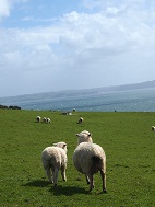
Fact of the day: NZ has a population of 4.2 million people... and 40 million sheep. Baaaaaaaaa
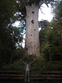
Second Fact of the Day: This Kauri tree that Jonathan is standing in front of is 13m wide, 50m tall and almost 2 000 years old!!!
ps. HAPPY BIRTHDAY, LOOCH!!
happy birthday to you, happy birthday to you, happy birthday dear loochy, happy birthday to you!
6 comments:
awwww i love you guys!!! miss you lots!! thanks for the post!! pics look amazing!! have a good time in nz!!! xoxoxoxoxo
did you pack an inflatable dingy?
happy birthday karly!!!
Hi J and K,
I'm enjoying reading you Blog and look forward to each one. You are having a great time in New Zealand and, like Nanny and I, you have fallen in love with it.
I remember those lovely white sandy beaches. Your pictures and commentary and supreb. Best wishes.
Pappy.
Obviously you both should have paid more attention during your Enviromental Studies course. Tides 101.
Why does this not surprise me!!!!!
Your photos are getting a little better daughter.
Love dad
Post a Comment